


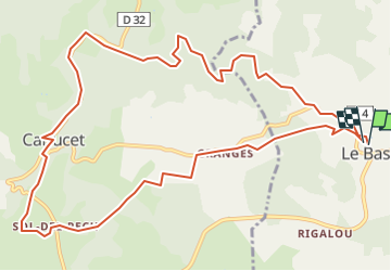
Le Bastit Carlucet 2-7836037

houbart
User

Length
13.6 km

Max alt
350 m

Uphill gradient
218 m
Km-Effort
16.6 km

Min alt
233 m

Downhill gradient
222 m
Boucle
Yes
Creation date :
2022-12-04 15:06:46.015
Updated on :
2022-12-04 15:07:26.176
3h45
Difficulty : Difficult

FREE GPS app for hiking
 SityTrail
IGN / Geographical institutes
SityTrail Plus
The world is yours!
About
Trail Walking of 13.6 km to be discovered at Occitania, Lot, Le Bastit. This trail is proposed by houbart.
Positioning
Country:
France
Region :
Occitania
Department/Province :
Lot
Municipality :
Le Bastit
Location:
Unknown
Start:(Dec)
Start:(UTM)
394318 ; 4952946 (31T) N.
Comments